- WEATHER: Short-term (day-to-day) changes in atmospheric conditions.
Temperature changes are caused primarily by the warmth of the sun during the day (more in summer than in winter) and by
heat loss (by both conduction and air convection) at night.
The warming and cooling effects are both favored by clear skies; both are slowed down by cloud cover.
Wind circulation also affects temperatures: winds blowing from polar regions or from relatively cool bodies of water will lower temperatures.
Winds blowing from warmer (more tropical) places will raise temperatures.
Pressure changes are caused, in part, by temperature differences. Warm air near the surface tends to rise, reducing pressure. Cold air sinks, raising pressure.
High pressure drives clouds and moisture away, ushering in fair weather in many cases. Conversely, low pressure sucks in clouds, moisture, and storms.
For this reason, barometric pressure is the single best predictor of short-term weather change.
(This discovery was first made in the Renaissance by Evalgelista Torricelli, the inventor of the barometer.)
Pressure cells (ridges and depressions):
Remember that local differences in air pressure cause winds to flow from high pressure areas to low.
Remember also that the Coriolis effect causes moving air to turn to the right in the Northern Hemisphere, or to the left in the Southern Hemisphere.
Thus, in the Northern Hemisphere, winds flowing outward from a high pressure area will turn to the right and form a clockwise spiral (an outward spiral).
Likewise, in the North, winds flowing into an area of low pressure will turn to the right of center and circulate counter-clockwise (an inward spiral).
(Clockwise and counter-clockwise directions are reversed in the Southern Hemisphere.)
AIR MASSES and FRONTS:
- Maritime Tropical (mT) air masses are moist and warm. They commonly arise over the Gulf of Mexico and the Caribbean Sea and bring lots of moisture to the eastern U.S.
These air masses may linger in the South, or they may drift north, bringing fog, drizzle, and stratus or stratocumulus clouds. They may occur at any time of year, but are more common in the summer, when they are responsible for hot, humid weather spells.
- Maritime Polar (mP) air masses are cold and moist. They commonly occur in the northern Pacific, bringing fog and rain to the Northwestern states (Washington, Oregon).
These air masses can also occur in the north Atlantic and bring storms to the New England states and to the Canadian Maritimes.
- Continental Polar (cP) air masses are cold and dry, usually large, and usually stable for days at a time. They arise over polar regions and slowly move towards middle latitudes (from Canada into the U.S.) and then eastward.
These air masses can occur at any time of year, but more frequently in the winter, when they may dominate the weather for days at a time over the northern U.S.
During the winter months, an especially cold air mass, called Continental Arctic (cA), can also briefly form.
- Continental Tropical (cT) air masses are confined to desert regions (like the Southwestern U.S.) and to summer months.
The air rises to mid-level altitudes and then spreads. When cT air collides with moist (mT) air, severe thunderstorms often result.
These air masses bring scorching heat to desert regions, but they seldom spread very far.
-
- Warm front:
When a warm air mass advances against a colder air mass, the advancing boundary is called a warm front.
- Cold front: Conversely, when a cold air mass advances against a warmer air mass, the advancing boundary is called a cold front.
- Storms often develop along the boundaries of a cold front or a warm front, or just ahead of the advancing front.
This is especially likely when the warmer air mass is moist (humid), because the cold air cools the warm air down to its dew point, causing precipitation.
- Symbolism: The forward direction of a cold front is shown by sharp triangles, representing the sharp, biting cold. The forward direction of a warm front is shown by rounded symbols with gentle surfaces to show that the warmth is gentle.
On a stationary front, the triangles are on the cold side and the rounded symbols on the warm side. On an occluded front, both symbols are on the same side, in the direction of movement.
- Stationary front: A non-moving boundary between a cold air mass on one side and a warm air mass on the other.
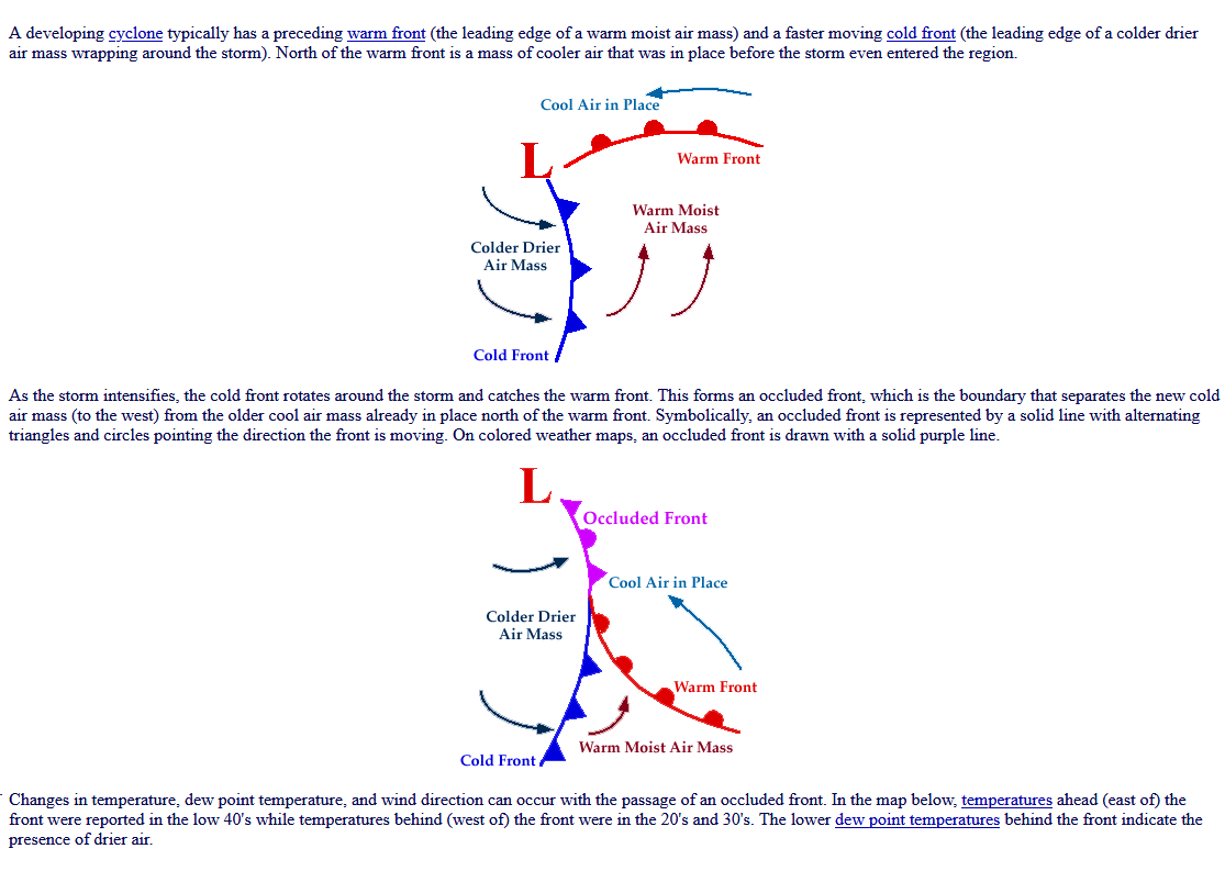
- Occluded front: A special type of front that develops from a large cyclonic circulation, as follows:
|