- GENERAL:
Locations on the Earth's surface are measured in Latitude and Longitude.
Latitude and longitude are measured in degrees of arc. There are 360 degrees in a complete circle.
Fractional degrees can be specified as decimals, or as minutes and seconds. A minute of arc is 1/60 of a degree,
and a second of arc is 1/60 of a minute.
- LATITUDE:
Latitude is a measure of angular distance from the Equator. The Equator is at 0 degrees latitude.
Lines of equal latitude are called parallels.
Locations in the Northern Hemisphere are considered "North latitude" or positive. The North Pole is at 90 degrees N latitude.
Locations in the Southern Hemisphere are considered "South latitude" or negative. The South Pole is at -90 degrees or 90 degrees S.
From the Renaissance on, latitude was measured by measuring the altitude in the sky of Polaris, the "North Star".
In the Northern Hemisphere, the height of Polaris in the sky is a measure of your latitude.
(Polaris is not exactly above the North Pole;
it is a fraction of a degree off, but we will ignore that.)
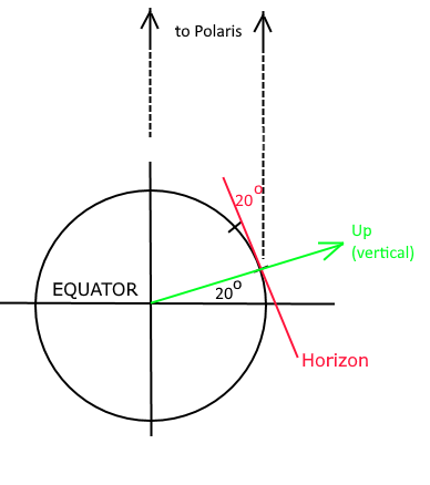
To an observer at 20oN latitude,
Polaris has an altitude of 20o above the horizon.
|
| 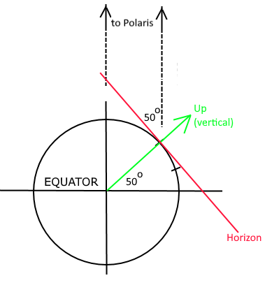
To an observer at 50oN latitude,
Polaris has an altitude of 50o above the horizon.
|
- LONGITUDE:
Longitude is a measure of the angular distance East or West of a reference point.
The reference point now used is the Royal Observatory in Greenwich, England, outside London.
Lines of equal longitude are called meridians. The meridian of Greenwich is called the Prime Meridian (longitude zero).
Longitude was always more difficult to measure. Because of the Earth's rotation, the Sun rises earlier in locations further east.
For every 15 degrees of longitude (that's 1/24 of 360 degrees) further east, the sun rises one hour earlier.
Local noon, where the sun reaches the highest point in the sky, is also one hour earlier for every 15 degrees of longitude further east.
Travelers (including ships at sea) could measure their longitude only if they could measure both:
- The time of local noon (or some other astronomical event), and
- The time of that event on a clock that kept time with the Royal Observatory in Greenwich.
Clocks that could keep accurate time on long ocean voyages were not developed until the nineteenth century.
Nowadays, latitude and longitude are determined by measurements taken from Earth-orbiting satellites.
On a flat map, East Longitude increases to the right. If you go off a world map to the right,
you come back from the left margin,
still moving right to go East, until you reach the International Date Line (180 degrees East or West).
Similarly, West Longitude increases to the left, and you can go off the left margin of the map and come back from
the right margin, still moving left to go further West.
- TIME and TIME ZONES:
If the time of local noon at your location is EARLIER than noon in Greenwich, then your longitude is EAST by 15 degrees for every hour earlier.
If local noon at your location is LATER than noon in Greenwich, then your longitude is WEST by 15 degrees for every hour later.
Remember: "If the time is LESS, you are WEST; if the time has INCREASED, you are EAST."
Similarly, if sunrise or any other astronomical event is EARLIER in your location than the same event in Greenwich, then you are EAST of Greenwich,
and if the event at your location is LATER than it is in Greenwich then your longitude is WEST of Greenwich.
The entire world is divided into 24 time zones, each approximately 15 degrees of longitude wide.
(Many countries deviate from this pattern for political reasons. China, for example, is all one time zones even though
it spans nearly 60 degrees of longitude.)
For a map of the actual time zones currently in use,
click here.
|